


It’s Not Optional,
It’s Essential for DFR.


AI-Powered Virtual Visual Observer for Public Safety
When lives are on the line, every second counts. DedroneBeyond enables public safety agencies to deploy Drone as First Responder (DFR) solutions without requiring on-site visual observers. Remote Pilots in Control (RPIC) can operate drones safely from command centers while DedroneBeyond serves as a virtual visual observer, ensuring compliance and airspace safety.

Resource inefficient
Resource efficient
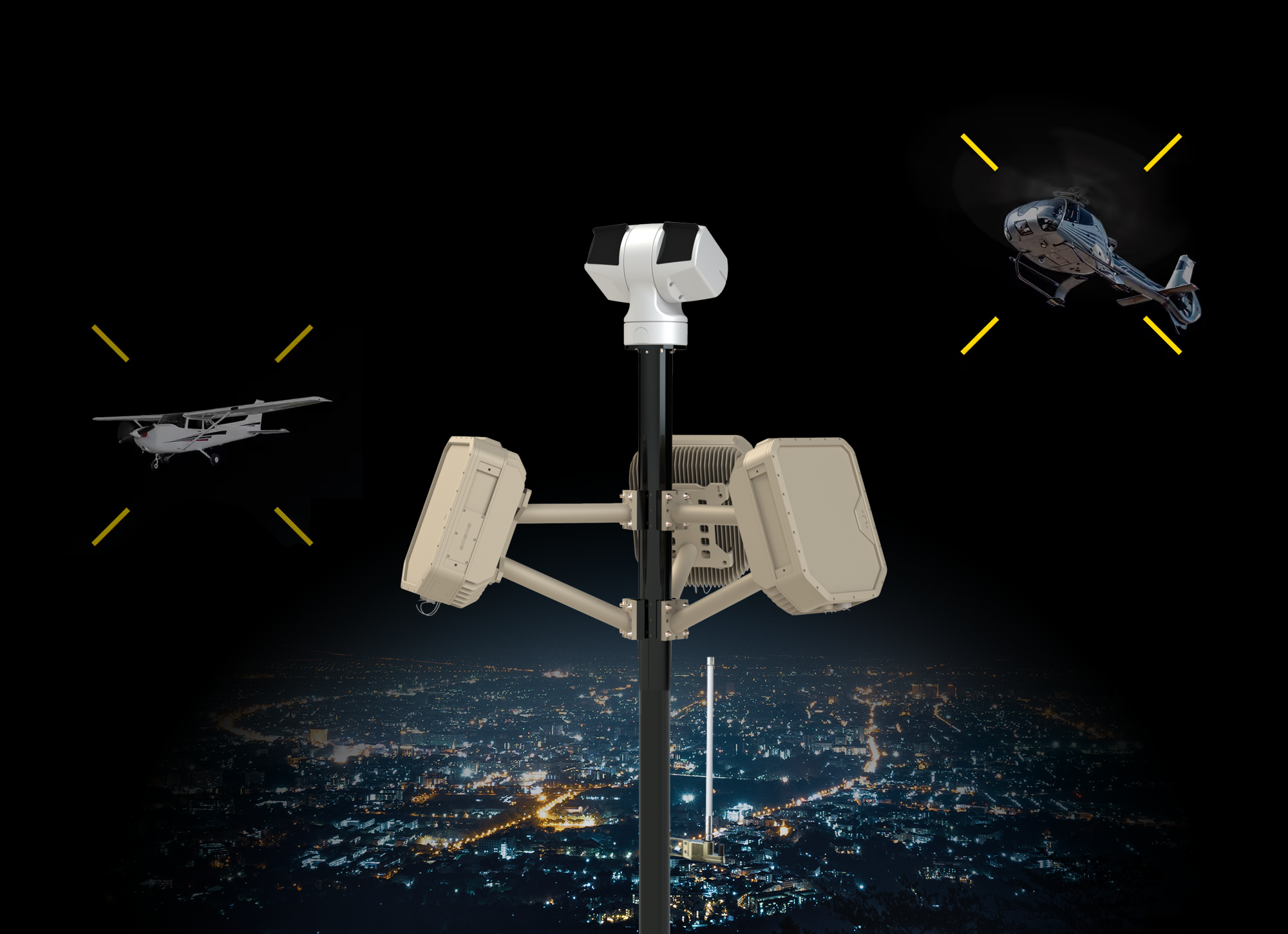
AI-Driven Sensor-Fusion vs. Simple Data Correlation
DedroneBeyond goes beyond basic data correlation by dynamically integrating multiple sensor inputs for superior accuracy and reliability.
ADS-B: Tracks cooperative aircraft flight paths and identification for safer navigation.
Best-in-Class Machine Learning
Powered by the largest annotated data set, fastest machines, and latest learning algorithm to enhance detection accuracy—virtually eliminating false alarms and filling coverage gaps.
Radar: Provides precise range and movement tracking for accurate aircraft positioning.
Cameras: Enables visual identification and classification, differentiating drones from other aerial objects.
Integrated Software: Provides airspace awareness to support deconfliction from crewed aircraft and higher altitude operations where authorized.
Long-Range Detect-and-Avoid System (DAA)
Our multi-layered approach ensures real-time BVLOS awareness, improving safety, minimizing false alarms, and building confidence in DFR (Drone as First Responder) missions.


Unlock Beyond Visual Line of Sight (BVLOS) Operations with DedroneBeyond
Faster Emergency Response
Gain real-time situational awareness before personnel arrive on the scene.
Enhanced Officer Safety
Provide aerial intelligence to reduce risk and better equip officers to handle threats effectively.
Continuous Incident Monitoring
Maintain ongoing aerial surveillance for better decision-making in dynamic situations.
Personnel
Optimization
Free up officers from rooftop observation duties, allowing them to focus on active response efforts.
Increased Operational Efficiency
Reduce reliance on manual surveillance and optimize resource allocation.
Advanced Airspace Awareness
Identify all aircraft types, ensuring secure and FAA-compliant operations.
This FAA approval is a major milestone for our department. With the ability to conduct drone operations day or night without the need for visual observers, we can respond faster and more effectively.
Expanding DFR Capabilities:
Flying from 0 to 400 Feet
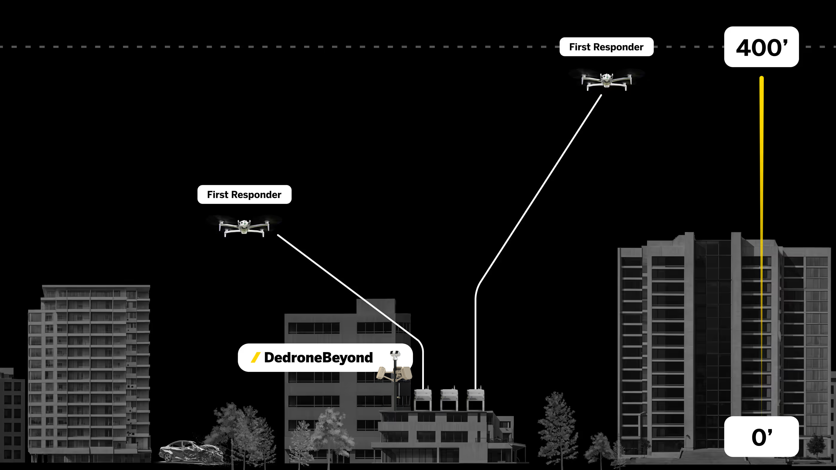
Greater Situational Awareness
Expanded aerial coverage for tracking multiple subjects and larger incidents.
Reduced Noise & Public Disruption
Higher altitude operations minimize sound pollution, improving discretion.
Enhanced Tracking for Search & Rescue
Improved ability to locate missing persons or monitor fast-moving incidents like vehicle pursuits.
Optimized Airspace Coordination
Seamless integration with crewed aircraft, maximizing flight endurance and mission effectiveness.
Low-Altitude Operations
Enables secure and strategic flight at lower altitudes, enhancing mission adaptability, even beyond shielded operations
Seamless Drone Fleet Expansion & NDAA Compliance
DedroneBeyond integrates with both existing and future drone fleets, ensuring smooth scalability. With Axon’s SkySwap Program, agencies can transition to NDAA-compliant, autonomous drone solutions, modernizing operations with secure, American-made technology while still leveraging their current drone fleet. DedroneBeyond empowers agencies to scale their DFR (Drone as First Responder) programs with confidence, ensuring safety, efficiency, and regulatory compliance in an evolving airspace landscape.
Get help with WaiverUnlock True BVLOS
You bring the mission. We bring:
to guide you through a successful FAA Certificate of Waiver (COW) process.


